Unveiling the Dynamics of Continental Rift Zones: Magmatism and Tectonics at Work
Continental rift zones stand as dynamic laboratories of Earth’s geological evolution. A continental rift zone is a region where the Earth’s lithosphere is being pulled apart due to extensional tectonics. These areas are characterized by active faulting, volcanic activity, and magmatic intrusions that reshape the crust. The interaction between mantle-derived melts, magma storage, and tectonic extension plays a crucial role in the evolution of rift systems. This article delves into the distinctive features of these processes, their implications, challenges, and opportunities for advancing geological understanding.
Context of Magmatic and Tectonic Processes
Introduction/Definition
-
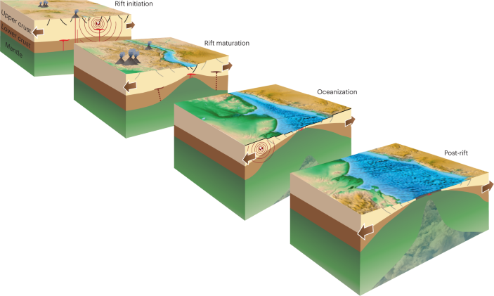
Definition and Formation: Continental rift zones occur where tectonic plates diverge, such as the East African Rift, stretching the lithosphere and thinning the crust over millions of years.
-
Key Interactions: Magmatism and tectonics together drive crustal modification, influencing volcanic landscapes and seismic activity.
DISTINCTIVE FEATURES
1. Magma Generation and Source (a, b, c):
-
Origin: Partial melts originate from the lithospheric mantle and accumulate at the crust-mantle boundary.
-
Composition: Magma composition varies from low-silica, alkali-rich magmas to silicic magmas depending on fractional crystallization and melt interactions.
-
Geological Role: These melts fuel volcanic activity, shaping rift topography.
2. Magma Storage and Reservoirs:
-
Shallow Reservoirs: Shallow magma reservoirs (5–10 km depth) serve as sources for volcanic eruptions, feeding surface features like lava lakes.
-
Deeper Zones: Deeper magma storage zones exist at ~20–40 km depth, influencing melt migration and long-term rift evolution.
3. Tectonic Extension:
-
Mechanisms: Extension occurs mainly by faulting (a, b) and dyke intrusion (b, c).
-
Pathways: Border faults and pre-existing weaknesses provide pathways for magma ascent, facilitating volcanic activity.
4. Volcanic Activity:
-
Surface Features: Scoria cones, lava flows, and lava lakes form at the surface, showcasing active volcanism.
-
Diversity: Carbonatite and basaltic volcanism highlight the diversity of magma types in rift settings. Silicic calderas and complexes develop through protracted fractional crystallization and crustal processes.
5. Crustal Deformation:
-
Processes: Deformation is linked to dyke intrusion, magma withdrawal/recharge, and magmatic-hydrothermal activity.
-
Structures: Silicic crystal mush zones form due to long-term fractional crystallization, influencing rift stability.
6. Evolution Stages (a–c):
-
Stage A: Early rifting with fault-controlled magma ascent, scoria cones, and flank eruptions.
-
Stage B: Mature rift stage with extensive melt presence, silicic caldera formation, and fault-guided magma migration.
-
Stage C: Advanced rift stage dominated by basaltic shield volcanism, shallow reservoirs, and silicic complexes.
-
Significance: Continental rift zones represent dynamic environments where tectonic extension and magmatism interact to shape the lithosphere. The processes of melt generation, storage, migration, and eruption evolve over time, producing diverse volcanic and structural features.
Implications of Rift Processes
Scientific Impact
-
Tectonic Insights: Rift studies enhance models of continental breakup, as seen in the Red Sea Rift’s transition to oceanic spreading.
-
Volcanic Forecasting: Understanding magma reservoirs improves eruption prediction, vital for the East African Rift’s 50 million residents.
Engineering and Economic Impact
-
Infrastructure Safety: Fault and volcanic data guide the design of roads and dams in rift zones like the Ethiopian Highlands.
-
Resource Exploration: Rifts host geothermal energy (e.g., Kenya’s 1,000 MW capacity) and mineral deposits (e.g., lithium), boosting economic potential.
Environmental and Societal Impact
-
Landscape Evolution: Volcanic features shape ecosystems, supporting biodiversity in the East African Rift.
-
Hazard Mitigation: Monitoring deformation reduces risks from earthquakes and eruptions, protecting communities.
Challenges
Analytical Challenges
-
Complexity of Mapping: Diverse magma types and fault networks complicate seismic and geochemical analysis, with errors up to 15%.
-
Depth Uncertainty: Locating deep reservoirs (20–40 km) requires costly deep drilling, limiting data resolution.
Operational Constraints
-
Field Accessibility: Studying active rifts like the Afar Triangle demands helicopter support, increasing costs by 20–25%.
-
Eruption Risks: Volcanic activity poses safety hazards, delaying fieldwork in regions like Ethiopia.
Environmental and Safety Risks
-
Ecological Disruption: Magmatic-hydrothermal activity can contaminate water sources, necessitating mitigation in rift ecosystems.
-
Community Displacement: Expanding rifts may displace populations, requiring resettlement plans.
Opportunities
Scientific Advancement
-
Advanced Imaging: InSAR and magnetotelluric surveys can map reservoirs with 30% greater accuracy, enhancing rift models.
-
Interdisciplinary Research: Collaboration with volcanologists and geophysicists could predict rift progression using AI.
Engineering Applications
-
Geothermal Energy: Tapping shallow reservoirs could add 2,000 MW to global capacity by 2030, supporting renewable goals.
-
Resilient Design: Fault data can optimize infrastructure, reducing damage costs by 10–15% in rift zones.